

Roadworks of some form are encountered by many road-users daily. Despite being a cause of frustration and disruption to transport networks, they are an absolute necessity to maintaining the health of highways, streets, underground infrastructure, and roadside assets. Roadside assets include many of the ubiquitous features of roads we take for granted, including streetlights, signage, bollards, and curbs. They are vital to safe and operational transport networks and yet, until now, technology to effectively monitor the ‘health’ of roadside infrastructure has not been available to the organisations responsible for maintaining it.
Vehicles equipped with Mobileye 8 Connect will capture Britain’s roadside characteristics and street furniture, including road markings, network boxes, traffic lights, road signs, lamp and telegraph posts, bollards, manhole covers, drainage grates, and more. In London on Tuesday, May 7, 2019, Ordnance Survey, Great Britain’s national mapping agency, and Mobileye, an Intel company, announced the launch of trials to create the first detailed roadside infrastructure dataset of Britain for an accurate and customizable location information service. (Credit: Ordnance Survey)
Among these groups, local authorities and utilities companies in the UK have experienced a ‘data gap’ with a lack of up-to-date visibility on the location and condition of roadside assets. This may result in delays in maintenance, until damage or degradation has reached the point of causing potential danger to road users. Indicators of potential issues, such as blocked drains that would cause floods – along with havoc for water companies – often go unnoticed until major repairs or roadworks must take place, causing severe disruption.
A world-leading initiative driven by Britain’s national mapping agency, Ordnance Survey, utilises vehicle-mounted image recognition technology to build ‘intelligent’ maps of roadside assets – in near real-time. By expanding the visibility of transport networks, it enables better management of highway infrastructure, including rapid and precise targeting of maintenance, and alerts on changes to assets, ensuring safer and more operational roads.
The service can supply local authorities, power, and utilities companies with up-to-date and accurate information on their assets, allowing maintenance crews to be sent to exact locations where repairs are needed. This saves time and money for the organisations and avoids the need for more disruptive roadworks by spotting early warning signs of degradation. In the past year alone, the Roadside Asset Data Service (RoADS) program has mapped 1.5 million features and identified 16,600 areas of damage to outdated infrastructure. This includes depressions in the road that indicate imminent leaks, or that may cause road accidents, and road signs obscured by overgrowing vegetation.
The system uses computer vision technology, fitted on 100 vehicles, trained to detect and categorise the roadside assets, as well as capture data on the condition. Originally developed as an advanced driver assistance system (ADAS), it uses a camera to scan the road ahead for possible hazards. It warns drivers of a possible collision, giving them time to avoid it, or at least lessen its severity. It is a system that over the years has succeeded in helping fleets who use it to reduce overall collisions. Abellio London, for instance, was able to lower avoidable collisions by 30% after installing Mobileye.
Trials have been taking place in the North East of England to date, equipping the maintenance fleets of Northumbrian Water Group.

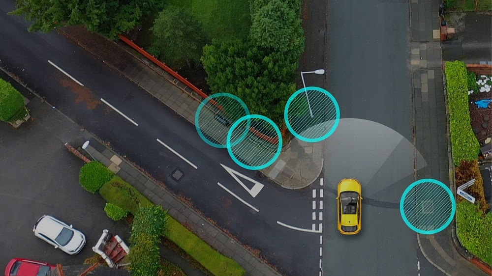
A vehicle retrofitted with Mobileye 8 Connect detects a construction area on its path, capturing the data as part of trials launched by Mobileye and Ordnance Survey. In London on Tuesday, May 7, 2019, Ordnance Survey, Great Britain’s national mapping agency, and Mobileye, an Intel company, announced the launch of trials to create the first detailed roadside infrastructure dataset of Britain for an accurate and customizable location information service. (Credit: Mobileye, an Intel Company)
Clive Surman-Wells, who leads Innovation Partnerships at Northumbrian Water Group, said “Accurate and reliable mapping of things like manholes, fire hydrants and valves helps us to be more efficient in our maintenance and repair work by finding things quickly first time, every time… we’re looking at how we can improve and complete our asset records by cross-referencing data collected from vehicle-mounted image-recognition systems with Ordnance Survey mapping data and our own asset records.”
The technology also has the capability to monitor roadwork and construction taking place on our transport networks and help prevent damage to third-party infrastructure. This is crucial data in understanding how to manage and streamline road maintenance – in England, the average highway maintenance budget per local authority rose to £31.5m a year in 2019, with further economic damage caused by delays due to roadworks, impacting the operation of business and increasing the likelihood of accidents.
There is now exciting potential to expand the initiative nationwide, and integrate more customers and collaborators. Attached to further utilities, telecoms, and water maintenance fleets, capturing a street level view of Britain’s roads would illustrate the impact of everything from the introduction of new infrastructure to extreme weather events. Capable of capturing details down to road markings, network boxes, traffic lights, road signs, lamp and telegraph posts, bollards, manhole covers, and drainage grates, the potential for optimising road maintenance across the country and making better and safer roads is enormous.
RoADS represents a cross-industry, collaborative commitment to making transport networks more effective for everyone. This pioneering approach is essential if roads, and roadside infrastructure, are to keep pace with the incredible innovation being witnessed in the transport sector. We see this initiative as the start of a promising journey towards capturing, using and integrating data in groundbreaking ways – to enhance asset management, planning, and innovation in the diverse web of networks that make up this country’s infrastructure. We are actively looking for customers to embark on a discovery programme before the end of 2020, to collaborate together and develop the service before launch next year. To sign up for more information, visit www.os.uk/rads.
Author: Simon Navin, Head of High Definition Roads at Ordnance Survey


Boris
( Thursday, October 8, 2020 - 11:28 )
Love this. good read